
[This topic is pre-release and is subject to change.]
Easily bring dynamic mapping capabilities into your canvas apps by viewing the physical position of entities from a data source, or by inputting new physical locations.
Pan, tilt, zoom, and drag to center your map view. As you zoom out, the markers will optionally cluster to represent dense groups of data.
The current location of the user can also be represented on the map on mobile devices or web experiences.
The map component also supports road and satellite views.

To use the component, you need to enable geospatial features for the environment in addition to enabling geospatial features for each app that you want to use it in.
Use the component
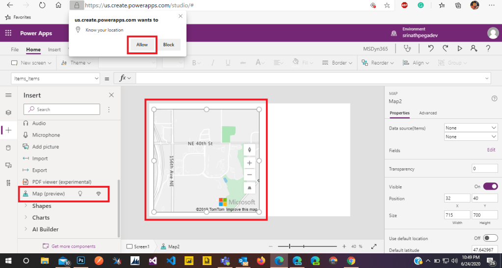
Insert the component into your app as you normally would for any other control or component.
With an app open for editing in the Power Apps studio:
- Open the Insert tab.
- Expand Media.
- Select the component Map to place it in the center of the app screen, or drag it to position it anywhere on the screen.
- (Optional) Select Allow in the window that asks to know your location. This enables the component to display the user’s current location.
You can modify the component by using a number of properties.
Properties
The following properties can be defined and configured in the component’s Properties pane.

Note that some properties are only available on the Advanced tab in the Properties pane, in the More options section.
| Property | Description | Type | Location |
| Data source(Items) | Data source (table) that lists a predefined set of longitudes and latitudes to display as map pin on the map when it’s loaded. Map each of the columns in your data by using the ItemAddresses, ItemLongitudes, ItemLatitudes, and ItemLabels. | Not applicable | Properties |
| Use default location | Whether the map initializes at a default location set by the user. | Boolean | Properties |
| Default longitude | Longitude the map would go to when it’s loaded if Use default location is enabled. | Floating point number | Properties |
| Default latitude | Latitude the map would go to when it’s loaded if Use default location is enabled. | Floating point number | Properties |
| Default zoom level | Zoom level the map would be set to when it’s loaded if Use default location is enabled. | Integer | Properties |
| Show current location | Whether the map should display the current location of the user (if it has permission). | Boolean | Properties |
| Satellite view | Whether the style of the map is a satellite view or a road view. | Boolean | Properties |
| Cluster pins | Whether the map pins are clustered.Whether the map pins are clustered. | Boolean | Properties |
| Zoom control | Whether the zoom component appears on the map. | Boolean | Properties |
| Compass control | Whether the compass component appears on the map. | Boolean | Properties |
| Pitch control | Whether the pitch component appears on the map. | Properties | |
| Pin color | The color of the pins. | Color picker | Properties |
| Maximum map pins | Maximum number of pins displayed on the map. | Integer | Properties |
| ItemsLabels | A column in Items with the strings you want to use as labels for the pins. | TableName.ColumnName | Advanced |
| ItemsAddresses | A column in Items with the strings that represent the location of the pins. Doesn’t work with ItemsLongitudes or ItemsLatitudes. | TableName.ColumnName | Advanced |
| ItemsLongitudes | Name of the column in the table in your data source with floating-point numbers that represent the longitude position of the pins. Doesn’t work with ItemsAddresses. | TableName.ColumnName | Advanced |
| ItemsLatitudes | Name of the column in the table in your data source with floating-point numbers that represent the latitude position of the pins. Doesn’t work with ItemsAddresses. | TableName.ColumnName | Advanced |
| Items_Items | Name of the table in your data source that contains all the records that you want to plot in the map by using pins. Each row must have an entry for the label, longitude, and latitude for each row. | TableName | Advanced |

My partner and I stumbled over here coming from a different website and thought I should check things out. I like what I see so now i’m following you. Look forward to exploring your web page again.
LikeLike